
$28.02K
1
2

$28.02K
1
2
Trader mode: Actionable analysis for identifying opportunities and edge
This market will resolve to “Yes” if, according to the ISW map, Russia captures the intersection between Derzhavna Vulytsya and Slobozhanska Vulytsya located in Drobysheve, Donetsk Oblast,(49°02'31.4"N 37°43'54.7"E) by February 28, 2026, at 11:59 PM ET. The intersection will be considered captured if any part of the intersection is shaded red on the ISW map (https://storymaps.arcgis.com/stories/36a7f6a6f5a9448496de641cf64bd375) by the resolution date. If the area is not shaded red by the specif
Prediction markets currently give Russia a roughly 1 in 3 chance of capturing the key intersection in Drobysheve, Donetsk Oblast, by the end of March. This means traders collectively see a Russian advance into this specific village as possible but not the most likely outcome in the short term. The low trading volume, about $28,000, suggests this is a niche question followed mainly by those closely tracking frontline movements.
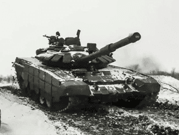
The modest 35% probability reflects the slow, grinding nature of the current fighting in eastern Ukraine. Drobysheve is located west of Bakhmut, an area where Russian forces have made incremental gains but at a high cost. The village itself is small, but controlling its crossroads could support further operations toward larger Ukrainian-held towns like Chasiv Yar.
Two main factors shape these odds. First, Russian forces have concentrated their offensive pressure on this sector of the front, committing significant resources to achieve tactical advances. Second, Ukrainian defenses in the Donbas have proven resilient but are strained by ammunition shortages and stretched lines. The market price essentially balances observed Russian momentum against the historical difficulty of securing even small settlements quickly.
The resolution date for this specific market is March 31. The primary factor to watch is the daily mapping from the Institute for the Study of War (ISW). If their map updates show the intersection shaded in red, indicating Russian control, the market will resolve to "Yes." Significant shifts could also come from broader battlefield events, like a Ukrainian withdrawal from nearby key terrain or a sudden Russian breakthrough that accelerates the local timeline. Major changes in Western military aid to Ukraine in the coming weeks could also influence the pace of fighting here.
Prediction markets have a mixed but interesting record on geopolitical and military events. They often aggregate dispersed information effectively, but their accuracy can suffer when dealing with low-liquidity questions about specific tactical outcomes. This market has a relatively small amount of money wagered, which means it may be more sensitive to new information but could also be less stable than heavily traded questions. For niche military forecasts like this, they are best viewed as a snapshot of informed sentiment rather than a sure bet. The direct link to the objective ISW map data does provide a clear, unbiased resolution standard, which improves the forecast's integrity.
Prediction markets assign a 35% probability that Russian forces will capture the specified intersection in Drobysheve, Donetsk Oblast, by March 31, 2026. This price, derived from a thin $28,000 market on Polymarket, indicates the consensus views a Russian capture as unlikely within the 30-day window. A 35% chance translates to a clear, though not definitive, expectation of Ukrainian defense holding the position. The market resolves based on the Institute for the Study of War's (ISW) daily conflict map, a trusted source for territorial control.
The low probability reflects the current operational tempo on this front. Drobysheve is located northwest of Bakhmut, an area where Russian advances have been measured in meters, not kilometers, for most of 2024 and early 2025. Recent ISW reports note that Russian offensive pressure in the Siversk direction, which includes Drobysheve, has been persistent but largely inconclusive, failing to achieve major breakthroughs. The 35% price accounts for this grinding attritional warfare where small tactical gains are possible but capturing a specific defined point within one month is statistically unfavorable based on recent history. The market effectively prices the high cost Russian forces pay for marginal advances against prepared Ukrainian defenses.
The odds will shift with observable changes in the frontline. A sudden concentration of Russian artillery and assault units near Siversk, documented in geolocated footage or noted in daily ISW assessments, would cause the "Yes" share price to rise. Conversely, verified reports of a successful Ukrainian counterattack or reinforcement in the sector would drive the probability lower. The market is highly sensitive to the ISW's map updates. A single day where the map shades the target intersection red would immediately resolve the market to "Yes." Therefore, traders are betting on the absence of such a shading event over the next 30 days. A breakthrough in nearby Chasiv Yar could also alter the strategic picture and increase pressure on the Drobysheve area, making it a key indicator to watch.
AI-generated analysis based on market data. Not financial advice.
This prediction market focuses on whether Russian forces will capture a specific intersection in Drobysheve, a village in Donetsk Oblast, Ukraine, by February 28, 2026. The resolution depends on the Institute for the Study of War's (ISW) daily interactive map, which uses a color-coded system to track territorial control. The intersection between Derzhavna Vulytsya and Slobozhanska Vulytsya will be considered captured if any part of it is shaded red, indicating Russian control, on the ISW map by the deadline. Drobysheve is located approximately 25 kilometers northwest of the city of Sloviansk, a major Ukrainian stronghold in the Donbas region. The village sits along a potential axis of advance for Russian forces pushing westward from the previously captured city of Lyman. The question reflects the ongoing, grinding nature of the war in eastern Ukraine, where territorial gains are often measured in small villages and key road junctions rather than large cities. People are interested in this specific prediction because it serves as a microcosm of the broader conflict. It tests the momentum of Russian offensive operations in the Donetsk sector and the resilience of Ukrainian defensive lines. The outcome provides a measurable data point on the war's progress, with implications for military strategy, humanitarian conditions, and geopolitical analysis. The use of the ISW map as an objective arbiter adds credibility, as the institute is a widely cited and non-partisan source for conflict mapping.
Drobysheve's significance is rooted in the broader history of the war in Donbas. The village is located in Donetsk Oblast, one of four regions Russia claimed to annex in September 2022, despite not fully controlling them. Fighting in this area intensified after Russia's capture of the strategic city of Lyman in May 2022. Ukrainian forces recaptured Lyman in a counter-offensive in October 2022, pushing the front line eastward. However, Russian forces retook Lyman in a subsequent offensive, consolidating control by the end of 2022. Since that time, the front in northern Donetsk has stabilized somewhat, with fighting concentrated around a series of villages northwest of Lyman, including Yampol, Torske, and Drobysheve. This area has seen incremental, bloody combat reminiscent of the World War I-style trench warfare that characterizes much of the Donbas front. The capture of Drobysheve would represent the next logical step in a Russian advance from Lyman toward the Sloviansk-Kramatorsk agglomeration, which has been a key Ukrainian defensive hub since 2014. Historically, control of road junctions like the one specified in the prediction has been critical for mechanized advances and logistical supply, making them primary military objectives.
The capture of Drobysheve matters because it would bring Russian forces closer to Sloviansk, a city of over 100,000 people before the war and a major administrative center for Ukrainian forces in Donbas. Controlling this village would provide Russian artillery with improved positions to shell Ukrainian supply lines on the E40 highway, which runs into Sloviansk. This could strain the defense of a critical urban area. For the approximately 500-1,000 civilians who may remain in or near Drobysheve, a Russian capture would mean subjection to Russian occupation policies, including filtration procedures, potential conscription, and imposition of Russian curricula in schools. On a tactical level, a Russian success here would demonstrate an ability to make persistent, if slow, gains despite Ukrainian fortifications and drone surveillance. It would signal that Russian offensive pressure in Donetsk remains potent, potentially influencing Western calculations about military aid to Ukraine. Conversely, a Ukrainian defense that holds Drobysheve would affirm the strength of layered defensive lines built over the past two years and buy time for Ukraine to reconstitute forces for future operations.
As of late 2024, Drobysheve remains in a contested grey zone along the front line northwest of Lyman. The ISW map typically shows the area with a pink striped pattern, indicating active fighting with no clear control. Russian forces, likely elements of the 2nd Combined Arms Army, have made gradual pushes toward the village from the east, but Ukrainian brigades have conducted local counter-attacks. The fighting is characterized by intense artillery duels, FPV drone strikes, and small infantry assaults. The village itself is almost certainly destroyed. The immediate military focus in the broader sector has alternated between pushes toward Drobysheve and attacks further south toward Chasiv Yar, with Russian resources shifting between these axes based on tactical opportunities.
The ISW map is a daily, interactive conflict map created by the non-profit Institute for the Study of War. It uses geolocated information from satellite imagery, social media, and official reports to visually depict which side controls specific areas in Ukraine. It is a primary source for governments and journalists tracking the war's front lines.
Drobysheve is a small village in Donetsk Oblast, eastern Ukraine. Its geographic coordinates are 49.0426°N, 37.7319°E. It is situated roughly 25 km northwest of the city of Sloviansk and approximately 15 km west of the previously captured city of Lyman.
The intersection of Derzhavna and Slobozhanska streets likely represents a key road junction within the village. Controlling such junctions is militarily significant for maneuvering vehicles, establishing checkpoints, and securing supply routes. For the prediction market, it provides a precise, mappable location to determine control.
On the ISW's standardized map legend, areas shaded solid red indicate territory assessed to be under Russian control. Areas in solid blue are under Ukrainian control. Pink stripes indicate areas of contested control or active fighting. The market resolves to 'Yes' if any part of the specified intersection is solid red.
Educational content is AI-generated and sourced from Wikipedia. It should not be considered financial advice.
2 markets tracked

No data available
| Market | Platform | Price |
|---|---|---|
![]() | Poly | 35% |
![]() | Poly | 31% |


No related news found
Add this market to your website
<iframe src="https://predictpedia.com/embed/rLn6Vc" width="400" height="160" frameborder="0" style="border-radius: 8px; max-width: 100%;" title="Will Russia capture Drobysheve by...?"></iframe>